


Plan du Castellet - Gros Cerveau

soca
User
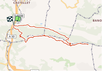

Length
10.2 km

Max alt
418 m

Uphill gradient
447 m
Km-Effort
16.1 km

Min alt
37 m

Downhill gradient
445 m
Boucle
Yes
Creation date :
2020-11-28 20:55:54.675
Updated on :
2020-11-28 21:05:29.664
4h00
Difficulty : Medium

FREE GPS app for hiking
 SityTrail
IGN / Geographical institutes
SityTrail Plus
The world is yours!
About
Trail Walking of 10.2 km to be discovered at Provence-Alpes-Côte d'Azur, Var, Le Castellet. This trail is proposed by soca.
Positioning
Country:
France
Region :
Provence-Alpes-Côte d'Azur
Department/Province :
Var
Municipality :
Le Castellet
Location:
Unknown
Start:(Dec)
Start:(UTM)
725069 ; 4783040 (31T) N.
Comments